Geoinformatics
Services

Geoinformatics service provides the digital mapping of estate infrastructures. The digital mapping is inclusive of mapping of buildings or hut, mapping of ponds, rivers, drainage, and many others. The measurement of hectarage are based on our GPS measurement.

INTRODUCTION
Geoinformatics service provides the digital mapping of estate infrastructures. The digital mapping is inclusive of mapping of buildings or hut, mapping of ponds, rivers, drainage, and many others. The measurement of hectarage are based on our GPS measurement.
AVAILABLE GEOINFORMATICS SERVICE
Digital Mapping Of Estate Infrastructures
Service Includes & Terms and Conditions:
- Development of Estate digital mapping.
- Digital mapping is inclusive of the following if applicable:
– Estate border identification
– Border identification subdivided to blocks under the same estate.
– Mapping of building or hut
– Mapping of ponds
– Tarred roads, primary estate roads, and secondary estate roads
– River, drainage and canals
– Bridge (wood-, steel- or concrete-type)
– “Digitizing” of Peta Tanah provided by estate owner - Cloning planting materials according to customer specific need.
- Data is given in the format of WGS84 or equivalent.
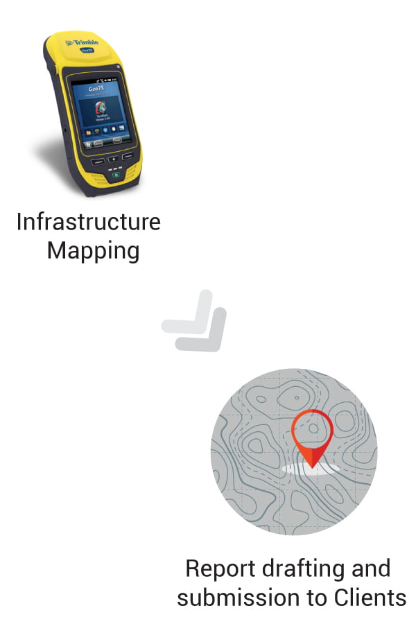
- A hard- and soft-copy of report in A4 size is given to the clients with a print copy of the infrastructure map with A0 size.
- Digital map data is given in the GIS shapefile (.shp) format and is copied in Compact Disc/Pendrive.
- Measurement of hectarage are based on our GPS measurement.
Digital Mapping Of Estate Infrastructures
Service Includes & Terms and Conditions:
- Development of Estate digital mapping.
- Digital mapping is inclusive of the following if applicable:
– Estate border identification
– Border identification subdivided to blocks under the same estate.
– Mapping of building or hut
– Mapping of ponds
– Tarred roads, primary estate roads, and secondary estate roads
– River, drainage and canals
– Bridge (wood-, steel- or concrete-type)
– “Digitizing” of Peta Tanah provided by estate owner - Cloning planting materials according to customer specific need.
- Data is given in the format of WGS84 or equivalent.
- A hard- and soft-copy of report in A4 size is given to the clients with a print copy of the infrastructure map with A0 size.
- Digital map data is given in the GIS shapefile (.shp) format and is copied in Compact Disc/Pendrive.
- Measurement of hectarage are based on our GPS measurement.
Automated Palm Counting
Service Includes & Terms and Conditions:
- We provide industrial grade of automated palm counting service to oil palm plantations.
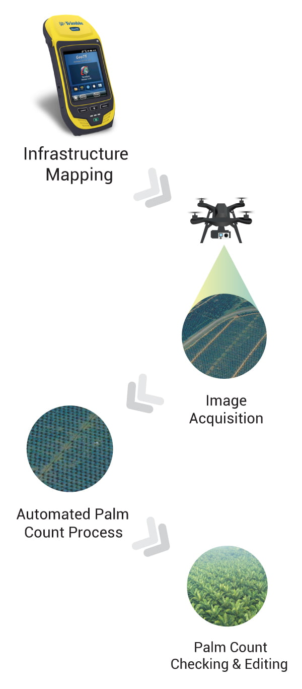
- We will conduct digital mapping of the boundary of the client’s estate.
- We use UAV/drone for digital mapping of palm trees for counting.
- For UAV imaging, the fly altitude is highly depending on the Earth topography of the client’s estates.
- Image resolution and digital surface model (DSM) is highly depending on the fly altitudes.
- Digital mapping is inclusive of the following if applicable:
– Estate border identification
– Border identification subdivided to blocks under the same estate.
– Mapping of building or hut.
– Mapping of ponds
– Tarred roads, primary estate roads, and secondary estate roads
– River, drainage and canals
– Bridge (wood-, steel- or concrete-type)
– “Digitizing” of Peta tanah provided by estate owner
– Palm counting map - The work is excluding of finding stone border of JUPEM.
- Data is given in the format of WGS84 or equivalent.
- A hard- and soft-copy of report in A4 size is given to the clients with a print copy of the map with A0 size.
- Palm count map data is given in the GIS shapefile (.shp) format and is copied in Compact Disc/Pendrive.
- UAV is given in Geotiff (.tiff) and ECW (.ecw) format.
- Measurement of hectarage are based on our GPS measurement.
Automated Palm Counting
Service Includes & Terms and Conditions:
- We provide industrial grade of automated palm counting service to oil palm plantations.
- We will conduct digital mapping of the boundary of the client’s estate.
- We use UAV/drone for digital mapping of palm trees for counting.
- For UAV imaging, the fly altitude is highly depending on the Earth topography of the client’s estates.
- Image resolution and digital surface model (DSM) is highly depending on the fly altitudes.
- Digital mapping is inclusive of the following if applicable:
– Estate border identification
– Border identification subdivided to blocks under the same estate.
– Mapping of building or hut.
– Mapping of ponds
– Tarred roads, primary estate roads, and secondary estate roads
– River, drainage and canals
– Bridge (wood-, steel- or concrete-type)
– “Digitizing” of Peta tanah provided by estate owner
– Palm counting map - The work is excluding of finding stone border of JUPEM.
- Data is given in the format of WGS84 or equivalent.
- A hard- and soft-copy of report in A4 size is given to the clients with a print copy of the map with A0 size.
- Palm count map data is given in the GIS shapefile (.shp) format and is copied in Compact Disc/Pendrive.
- UAV is given in Geotiff (.tiff) and ECW (.ecw) format.
- Measurement of hectarage are based on our GPS measurement.